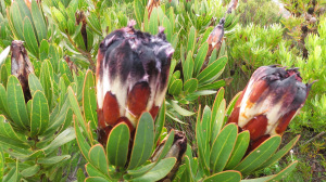
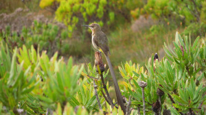
Also known as the Skyline Route, the unique aspect of this circular route, is the views it provides, of both False Bay on the one side and Hout Bay on the other. This combined with extensive stands of proteas, one or other of which seem to be flowering at most times of the year. Much of the lower part of the area was once covered by pine plantation, with the natural fynbos being re-established after the extensive fires of 1999 & 2000. Burnt again in 2015, the area has recovered well.

I have done this path many times over the years and have witnessed it’s different moods, brought on by different weather conditions, changes in the season and by more significant long term events such as fires. It is a route that can be done clockwise or anti-clockwise, with both directions being equally spectacular. For some reason the clockwise route seems to be faster. While it is not a difficult hike, there are a few short, steep scrambles that require you to use hands to hold on and take care of your foot placing, particularly when doing it anti-clockwise. It is the ideal hike for an early start and finish before lunch – about four hours, on the circular route that starts and finishes at the Silvermine Reservoir. Approximately 7 km, although there are excursions and links that can extend the route and on an ideal day, there are plenty of view points where one can spend time admiring the view. It is a route that does does frequently catch the wind and the mist.
It is an ideal hike for those who are comfortable on rocky terrain but do not want to do extreme scrambles. Highlights are the views Hout Bay from the top of Blackburn Ravine and ever changing perspective of this view all along the path to Noordhoek Peak, looking down on Chapman’s Peak and towards Noordhoek Beach. Some of the paths and links are not obvious and require a good knowledge of the area. Recommended that it is done with someone who knows the path, but an ideal path for a beginner hiker who is developing their hiking fitness.

Links:
The River Walk to extend the hike to the Silvermine Gate
The linear route to Chapmans Peak Drive
Paths to the north and south within the Silvemine Reserve
Grading: 2Cb – hiking path with uneven or stony surface